Reading New Testament Maps

Physical Features
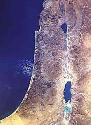
The two main differences between what we can see today from a satellite hovering over the east end of the Mediterranean Sea and what would have been seen two thousand years ago are first, that Lake Huleh north of the sea of Galilee is nearly gone. Also called the waters of Merom, Lake Huleh has been steadily silting up for millennia. By modern times, it was mostly a swamp, and from 1950 to 1958 over 12,000 acres of it were drained to become farmland. The second thing we would notice is that the Dead Sea has shrunk. It is literally drying up and is much smaller than it was in New Testament times.

Roman Palestine
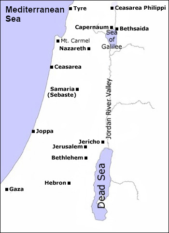
In 63-64 B.C., Judea (previously called Judah), along with Samaria and Galilee, came under Roman rule when Pompey intervened in a Jewish dynastic dispute. He was welcomed into Jerusalem by Hyrcanus II, a descendant of the Maccabean family which drove the Seleucid Empire's armies out of Israel generations before and had been allies with the Romans rather than their subjects (I Maccabees 1-8). After several generations of occupation, The Jewish people revolted against the Romans, and in retaliation, the Romans destroyed the Temple in 70 A.D.
Note the village of Nazareth where Jesus grew up.
Note the city of Samaria (sometimes the region is called Samaria and the city is called Sebaste).
Note the cities of Capernaum and Bethsaida on the Sea of Galilee. The region around the sea is also called Galilee.
Take the Roman Palestine map quiz.
Paul's Journeys

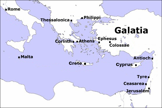
The Apostle Paul is known for his missionary journeys. This map lists the major cities he visited; although, it does not try to list all the cites mentioned in the accounts of Paul's journeys in the book of Acts.
Note the cities which received letters from Paul which ended up in our New Testament. (Galatians was written to Christians in the region of Galatia.)
- Rome
- Corinth
- Ephesus
- Philippi
- Colossae
- Thessalonica